National Weather Service: Level of Concern Growing For Weekend Storm
[THURSDAY MORNING 12/10 UPDATE]
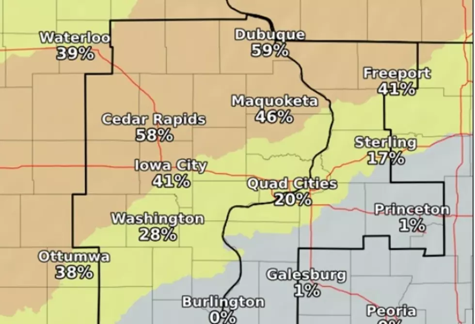
The latest update for Cedar Rapids from the National Weather Service shows rain should arrive in the area by late afternoon on Friday. It will change over to snow in the night and end by noon on Saturday. As you can see below, the Cedar Rapids area is in the heart of the area with the best potential for at least two inches of snow.

[ORIGINAL STORY] The fall of 2020 has been a dry one across the state but with winter just 12 days away, Mother Nature may be preparing to change her tune. As I write this, it's a beautiful 52 degrees in Cedar Rapids, but there's plenty of uncertainty about the upcoming weekend. Just how big the coming change will be is still to be determined.
A storm system is still about 48 hours away from Iowa and what exactly is going to happen with it, is still a big unknown. However, the National Weather Service posted this morning that the "Level of Concern For Impacts" from the storm is growing.
It's all expected to begin with rain Friday night with parts of the area likely to see it switch over to snow on Saturday. Where will the changeover occur and how much snow will fall? For now, meteorologist Terry Swails reports the EURO model is showing a narrow, but potent band of snow, just the south of Cedar Rapids and Iowa City.


The National Weather Service is calling for as much as 4 to 6 inches of total snow accumulation for Cedar Rapids for Friday night and Saturday.
We'll all be keeping a close eye on things over the next couple of days, as we know you will as well. Whatever happens, I'm ready. I spent part of my vacation putting fresh oil and gasoline in my snowblower. When this time of year arrives, you've got to be ready. Show me what ya got, Mother Nature.

KEEP READING: Get answers to 51 of the most frequently asked weather questions...
More From 94.1 KRNA